
This summer I had the chance to make two trips that inspired me to write this new post, a post that mixes history, evolution and biogeography. These trips unite both culture and evolutionary concepts, and exemplify how small, even minute outliers in our surroundings can carry the weight of thousands of years, to a time when these were, rather than outliers, the common norm. In Our croaky Gods: frogs across creational myths, we showed a case of cultural convergence; cultures on opposite sides of the globe getting similarly inspired by frogs, reflecting the same fears and questions on these animals through myths. Here, we talk about another convergence, between the evolution of languages and the evolution of forests, through the concept of “refugia“.
Ger, Bor, Das, Urtx, Ur: language rarities between France and Spain
This is a trip to my roots, the origin of one side of my family. Between northern Spain (Catalonia), and southern France, in the eastern side of the Pyrenees mountains, lies one of the biggest valleys in Europe: La Cerdanya (or Cerdagne in French). La Cerdanya connects Spain and France through the streams of the rivers Segre and Têt, and offers a safe pass through the Pyrenees. Family tales tell stories about refugees fleeing Spain through La Cerdanya during the Spanish Civil war (1936-1939) and French refugees using that same pass to flee from the German occupation of France during World War II. The story of the people of La Cerdanya, though, is a story of migration that goes way back in time. Remnants of that story are still hidden in minute details, outliers, which although visible to anyone, are hardly ever noticed.
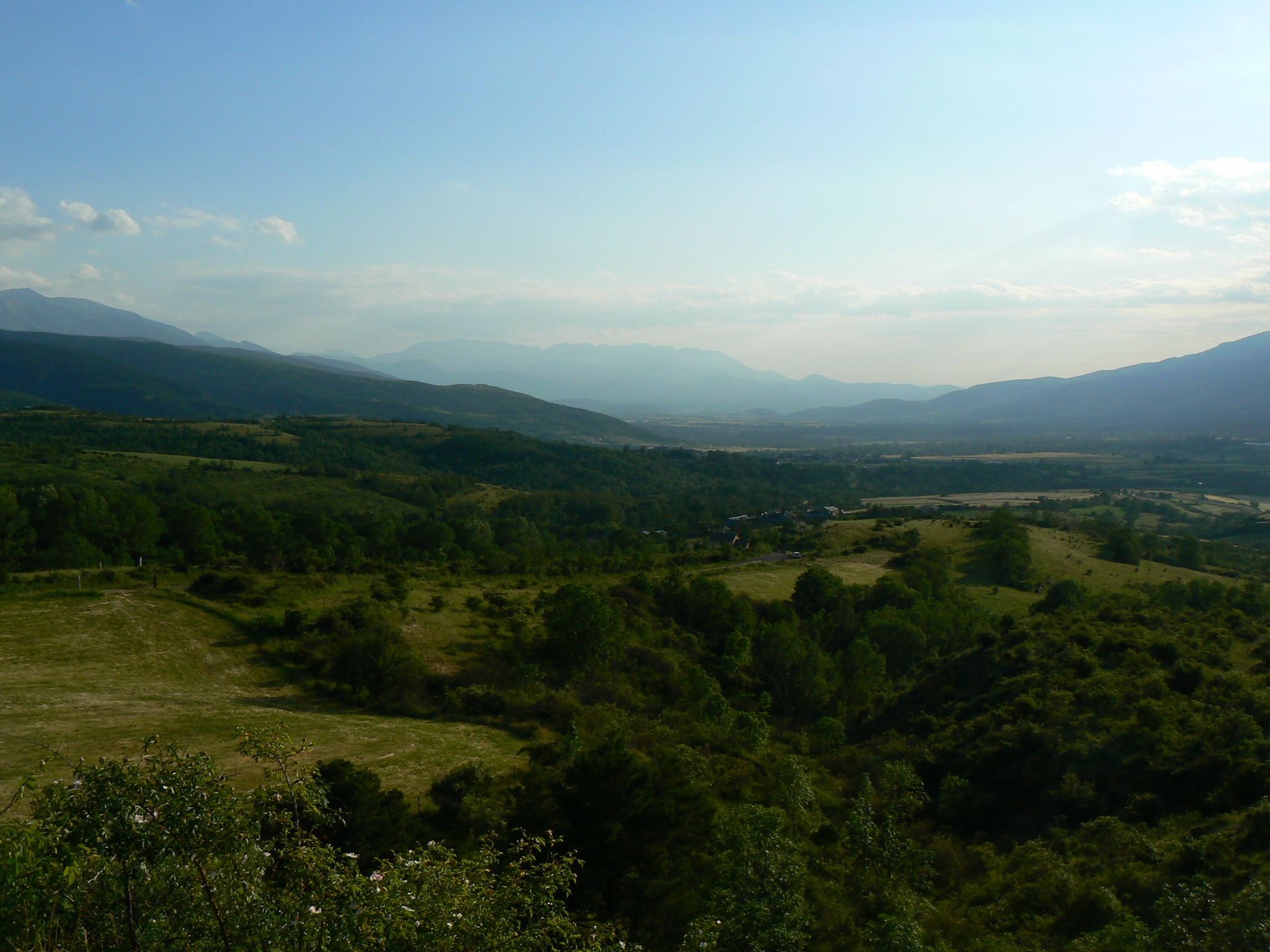
As a transitional area between two countries, the languages of the valley are diverse, and include the predominant French and Catalan, as well as Occitan and Spanish. All of these languages come from Latin, descendants from the occupation by the Roman Empire that began in 220 BC, which affected the whole history of southern western Europe. However, across La Cerdanya, one continuously encounters villages with… certainly strange names.
The strangeness of these names is hardly ever noticed by the thousands of people who visit the valley every year, and I myself was unaware until not long ago. These quirky names are many times just evident to linguists, but others are striking at first glance. These include a monosyllabic list of villages that goes by Ger, Bor, Das, Urtx, Ur, Lles, Llo, Er, Hix, Age… Not only is the density of monosyllabic toponyms strange in southern Western Europe, but none of them has a direct meaning in any of the languages present in the valley, or even an easy-to-guess origin.
So where do these names come from? One candidate is the language known as Basque. The ancient name of the village of Llivia, “Kerr” is very similar to the Basque word for stone, harri, while the village “Ur” is very similar to the Basque word for water ura. Basque (or better, Euskara) is spoken by a little bit more than half a million people across the Spanish-French regions close to the western Pyrenees. It is also a language isolate, meaning that there is no other similar language in the world, and it does not belong to any of the main language families we know of today. Its origin, then, is surrounded by mystery. Genetic evidence has shown that Euskara-speaking populations have been isolated for most of their history and that their origins date back to an ancient culture that spread through Europe before the Iron Age. Researchers believe that Euskara most possibly represents a lost language which was present across Southern Europe before the arrival of Iberian (one of the first languages in Spain, of uncertain origin) and before the arrival of any Indo-European language (which includes languages such as Hindi, Latin, German…). Current Euskara-speaking populations, then, represent a refugia: the remnants of a language and a culture that was previously widespread across southern Europe, but that is now secluded in the western side of the Pyrenees.
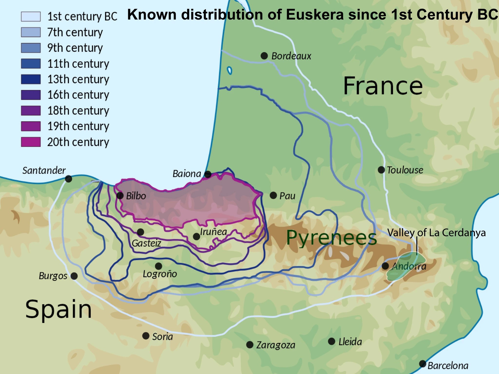
There is, though, no evidence that Euskara has been spoken in La Cerdanya, except by the names of the villages. In fact, not all researchers agree on a direct relation between these strange names and Euskara, and instead argue that this is not Euskara, but another, older language from the Iron Age, a proto-Euskara. This means that there is a bigger language gap between the villages in La Cerdanya “Ur” and “Llivia” (of Latin origin), than between “Llivia” and, for example, the name of the city of “Jaipur” in India (of probable Hindustani origin). The villages of La Cerdanya, then, represent refugia themselves: an indication that a proto-Euskara language was present there more than 6000 years ago. While both Iberians and later the Roman Empire used La Cerdanya as a pass through the Pyrenees, leaving their imprint on the region and erasing most of its history, the names of those villages up in the mountains, many times difficult to access, retained that cultural legacy.
The concept of refugia is especially interesting for the natural history of southern Europe, as well. During the Ice Ages (the Pleistocene; 2 million years ago, to 12000 years ago) most of northern Europe was covered by thick ice sheets. As the climate warmed up, these retreated, leaving space for plants and animals adapted to cold, dry weather. As the ice sheets retreated even more, and Europe became what it is today, these plants and animals disappeared, eventually. However, some still live today in specific places: the top of the mountains: the Alps and the Pyrenees. The Pyrenees, then, acted as a natural refugia, the last standing habitable place of this ancestral fauna and flora.
The laurel forest and a tropical Europe

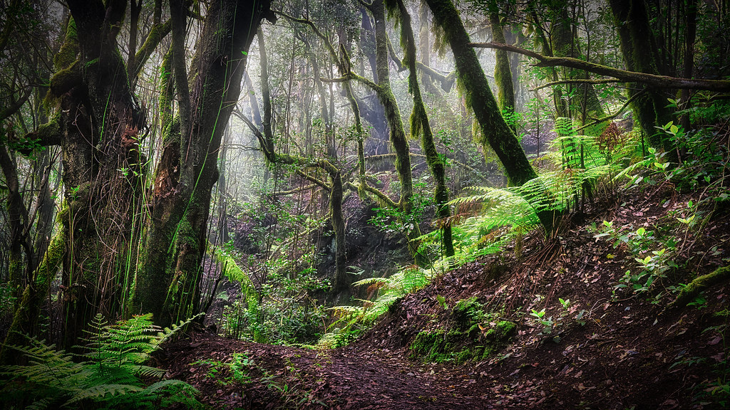
The second trip took me to a series of Atlantic volcanic islands on the west Saharan coast: the Canary Islands. These islands are situated in a transition zone between a subtropical climate and a temperate climate, providing an interesting mix of species. The islands are also under the influence of the north-easterly trade winds. These winds blow from northeast to southwest carrying clouds from the Atlantic. When these winds clash against the islands (some are higher than most mountains in the Pyrenees, strikingly), these clouds get trapped in the northern side of the islands, creating a sea of clouds that slowly condenses, creating the so-called “horizontal rain”. The shape of the island greatly influences which parts of the islands receive the “horizontal rain”, determining the type of vegetation they have. The island of La Gomera is a round-shaped island with its highest altitude in the centre, the Garajonay peak at 1485m in altitude. This creates a strong contrast between the northern and southern sides of the island and leaves a wide northern area influenced by the “horizontal rain”, mostly occupied by one type of forest: the laurel forest.
The laurel forest is a type of subtropical forest characterized by the presence of high humidity and evergreen vegetation, many times trees of the family of laurel (Lauraceae). Not all plants are from this family, but many show similar leaf shapes and adaptations, the result of convergent evolution: long waxy leaves that repel water and humidity, allowing leaves to breathe. The laurel forest is found worldwide, scattered in isolated patches where temperate stable temperatures and high humidity coexist. Islands like La Gomera are some of these isolated patches, but they are something else, as well: they are refugia.
Let’s go back in time, 15 million years ago, to the Miocene of continental Europe. This Europe is very different from the one we know of today. Temperatures are mild to subtropical, and humidity is high. It’s not difficult to see fauna and flora that we would normally associate with the sub-Saharan region: animals related to current rhinoceros, elephants, giraffes and even apes. Fossil plants found across Europe also tell us that the laurel forest was present, then. In fact, it was widely extended. Laurel forests reached far to the south and were similarly present in those Canary Islands that had, by then, emerged.
The Miocene is a turning point in our recent paleontological history, a tipping point between warm, subtropical temperatures and the upcoming Ice Ages. By the end of the Miocene, the laurel forest was already restricted to the southernmost parts of Europe, displaced by the increasingly cold temperatures. By the end of the Pliocene, two million years ago, the laurel forest had already disappeared from Europe, but it endured somewhere: in the Canary Islands and other Atlantic archipelagos.
Several of the plants we find today in the laurel forests of La Gomera (such as Pteris incompleta or Rhyncostegiella) are, then, relicts, survivors from the times when the laurel forest covered Europe, isolated in these Atlantic islands, their last refugia.
Both Euskara and the laurel forests are outliers that increase the diversity of both languages and ecosystems throughout Europe and the Atlantic. These outliers are historical relicts that bring us back to a time when these were the norm, rather than rarities, carrying a strong historical heritage that is worth protecting.
If you liked this, do not forget to follow us on Twitter and Facebook (click on the highlighted sections).
References
Behar, D. M., Harmant, C., Manry, J., Van Oven, M., Haak, W., Martinez-Cruz, B., … & Genographic Consortium. (2012). The Basque paradigm: genetic evidence of a maternal continuity in the Franco-Cantabrian region since pre-Neolithic times. The American Journal of Human Genetics, 90(3), 486-493.
Bruch, A. A., Uhl, D., & Mosbrugger, V. (2007). Miocene climate in Europe—patterns and evolution: a first synthesis of NECLIME.
Flores-Bello, A., Bauduer, F., Salaberria, J., Oyharçabal, B., Calafell, F., Bertranpetit, J., … & Comas, D. (2021). Genetic origins, singularity, and heterogeneity of Basques. Current Biology, 31(10), 2167-2177.
Kondraskov, P., Schütz, N., Schüßler, C., de Sequeira, M. M., Guerra, A. S., Caujapé-Castells, J., … & Thiv, M. (2015). Biogeography of Mediterranean hotspot biodiversity: re-evaluating the’Tertiary relict’hypothesis of Macaronesian laurel forests. PloS one, 10(7), e0132091.
Kovar-Eder, J., Kvaček, Z., Martinetto, E., & Roiron, P. (2006). Late Miocene to Early Pliocene vegetation of southern Europe (7–4 Ma) as reflected in the megafossil plant record. Palaeogeography, Palaeoclimatology, Palaeoecology, 238(1-4), 321-339.
Núñez, L. C., & Astrain, L. N. (2004). El euskera arcaico: extensión y parentescos. Txalaparta.
